Archive for the ‘Uncategorized’ Category

23
Jun
2005

DAY
23

Ok, I just did a quick mileage calculation and found that skipping Yellowstone will only save about 18 miles. That is great because I was thinking of heading east instead of north to Yellowstone because it seemed out of the way.

So, that being decided, I will head north into the Teton mountains on rt 20 looks like there is a pass into Yellowstone at 7072. Nice.

Today, I am riding into Craters of the Moon. I am at 4800 Ft now and I know I will be over 6000ft before I get to craters. So, lots of uphill today. I can see the mountains, they are beautiful should be a great ride.

« Older Entries Newer Entries »

22
Jun
2005

DAY
22

Today turned out to be a great day to ride. The sun was out and there was a head wind in the morning. Then, at about the hottest part of the day, there was a rest stop. Families were having lunch under the trees, and I took a nap. I am really growing to love the naps :)

When I woke up the clouds were covering the sun and the winds had changed. I jumped on my bike and followed this lush green valley for miles. There were snow capped mountains on my left and high brown mountains on the right. In the middle a carpet of green.

I passed through a small town called Picabo. What friendly people. The place I ate lunch was also a museum. They had some great old pictures. It was funny, they had pictures of people out hunting with Hemingway. The Hemingway. It turns out that after he lost his house in Cuba he moved to Ketchum, ID, about 35 miles from Picabo and spent a lot of time in the town. It was just him and a group of friends out and about. Ketchum is also where he shot himself. His house there is now a museum. While eating, I talked to a guy named Ken, who is working at a local nursery to save up for a trip next summer to South America. He was excited about skiing all summer (their winter) in Argentina. Great conversation.

Just outside of Picabo I also passed the world famous Silver Creek, known for it’s great trout fishing. I know this because I was sitting on the bridge over the creek watching the water go by and a lady on a bike stopped (at first I thought it was Lynn Blaney, a friend from Wheeling) and we talked about birds, the creek, the Oregon Trail, the snow covered mountains, and the animals. (Speaking of animals, I saw a fox hunting in a field of alfalfa yesterday. He was jumping up out of the clover and pouncing back out of sight. I waited and got a picture of him in midair!) Anyway, turns out this lady and her husband run a fishing tour company there at Silver Creek (hence the reason for all her knowledge about the area). It was great.

Over all I went about 50 miles today. A little short of my 70 miles a day goal, but it was a great day. I met some great people and saw some gorgeous country.

It is raining now, so, I set my tent up and will be sung to sleep by the pitter patter of rain on my tent. I am sure I will be dreaming of Craters of the Moon. Everyone says it is like the earth was bubbling away and then dried that way. We will see in the morning. I plan to take the 7 mile loop and do some hiking (another short mileage day)

Good night…

« Older Entries Newer Entries »

22
Jun
2005

DAY
22

I am at the junction of 20 and 75 about 26 miles east of Fairfield. I have been riding on a sections of the Oregon trail for about a week. I am on the Goodale’s Cutoff now. Here is some history about the route.

The Oregon Trail
In 1843 wagons first rolled past Fort Hall, ID and faced the harshness and desolation of the Snake River Plain. Dust, sagebrush, lava rock, mosquitoes, a burning sun, cold nights, rattle snakes and a concerened Native American population made the journey an arduous one. The journey across the ‘Great American Desert’ took five months,averaging 12 miles a day. After decade of heavy use by emigrants of the Oregon Trail and over utilization of resources created a need for new roads. Several alternate routes were created. Timothy Goodale, a former fur trapper, agreed to guide a large wagon train on an old Indian path discovered in 1820. Many were attempting to reach the newly discovered Salmon River gold mines along the new route.

Goodale’s cutoff as it was called became a regular Hudson’s Bay Company supply route between Fort Boise and Fort Hall. The road was rough and hard to navigate.

“The road winds around the foot of the mountain. Today’s drive was over the worst roads I ever saw, heard of or read of; they were so rocky. Some places the road is next to impassable. Actually, one of our wagons got wedged in between some large rocks or stones.”
-Eakin Family
July 20, 1866

“Started this morning, traveled through rocks from one to five feet high and had to make our road through the best we could. Some of the boys found in the rocks a trunk which was lost or hid in 1853. It was full of clothes, dishes and other small articles.”
-Nellie Slater
July 29, 1862

It has been interesting following the route of the Oregon Trail so far. I think that I might stick with it a little longer. Looks like it goes all the way to Independence, Missouri. I also enjoyed reading the quotes from people making the journey. Apparently there is a book of letters and journals of people who made the trip called ‘Letters and journals from the western trail 1840-1890′. It might have been interesting to have along the way.

« Older Entries Newer Entries »

22
Jun
2005

DAY
22

Wow! After the sun went behind the cloud it was a good day of riding. I crossed the mountain, the wind changed and it sprinkled to cool me off. I made it to my goal for the day.

I also passed 3 other cross country riders. They all started in Virginia. Nice people. The first guy I passed was on his 55th day of riding. He also was a communication major who took the ride to think.

The other two were kind of riding together. They were averaging 80 miles a day!!! And had only been riding for like 44 days. They were younger, just out of college.

I am up in the mountains again. It is much cooler and the valleys are lush. I found this great old country church just outside of Fairfield.

Tomorrow, I will be heading into Craters of the Moon National Monument. I am on St Rt 20 following the Goodale’s cutoff of the Oregon Trail. I should break 6000 Ft easy.

« Older Entries Newer Entries »

22
Jun
2005

DAY
22

5527 the highest yet. Not too bad of a ride either.

« Older Entries Newer Entries »

21
Jun
2005

DAY
21

Thought for the day:
A long strip of smooth asphalt is good for the soul.

addendum:
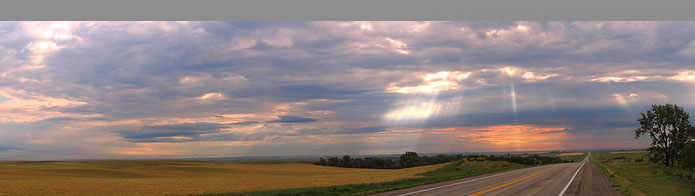
Rainbows are nice but they come as a package deal, you have to take the rain too. There is no free bow.

Butterflies are nice and have no such down side.

A strong tailwind can bring many, many happy miles.

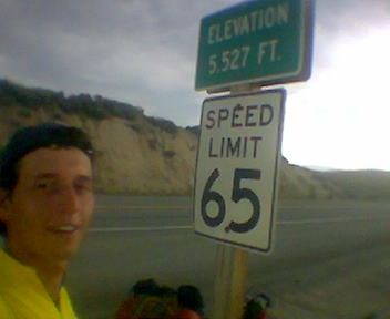
Today has been a hard ride. Last night, when I left Grand View I was at about 2400 Ft. This morning I set a new altitude record for the trip 5035 Ft.

Yes, it has been all up hill. :) The temp on the bike was at 103 and then the wind started blowing, hard. So, there I was riding up hill into the wind in the desert heat wondering what the heck I was doing.

So, I found a tree, took a nap in the shade. Then, ate some Oreos and drank some gatorade and enjoyed the cool breeze. The wind will change directions, the sun will set, and the temperatures will drop all in due time. Then I will ride, in the meanwhile I am going to enjoy some tunes on the iPod in the shade.

By the way, I expect the altitude record to fall very soon. I am at about 5000 Ft now and I see I large mountain in front of me. I am kind of excited to find out how high it really is.

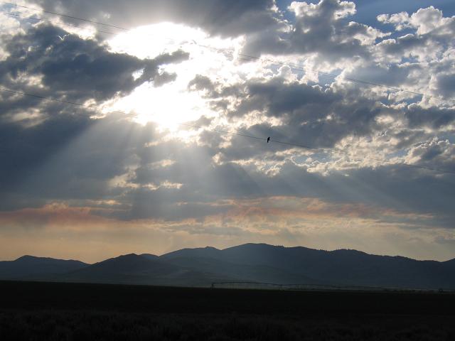
Wait, the wind has died down, and I think a rain cloud just covered the sun. Let me check.

Yes! It did…I had not thought of a cooling rain shower and no sun. Wow, I am on my way again!

« Older Entries Newer Entries »

21
Jun
2005

DAY
21

Well, yesterday was very interesting. I spent most of the day hiding from the heat at the public library in Grand View. Very nice people there. I had a great time.

Then about 5pm I started the 25 mile journey across the desert to Mountain Home. Ouch! Was it hot! The thermometer on my bike read 107.3!!!! It didn’t take long to get to Mountain Home although it seemed to be almost all up hill. A climb of about 1000 Ft.

Today, I am heading towards Fairfield. I was told that it is at about 5000 Ft. If so, that will be a climb of about 2000 Ft. and take me to my highest altitude of this trip. I hope it is cooler up there. I also pass through a town called Hill City (a little scary).

We will see…

« Older Entries Newer Entries »

20
Jun
2005

DAY
20

I had a request from Ryan to say ‘Hi’ to someone in Idaho and he got two for the price of one. This is Kathy and Willie from Grand View, Idaho. They are librarians at the public library. Both were pleased to receive the Pennsylvania greeting and sent a hardy ‘Howdy!’ back.

« Older Entries Newer Entries »

20
Jun
2005

DAY
20

I guess I need to catch everyone up. I got a flat tire about 5 miles from Parma, ID and so walked the bike into town where I stayed the night. It was good to sleep.

I went through Boise, ID yesterday. I ran by Northwest Nazarene College. Then headed out into the desert. Very hot! 101 Degrees with a head wind. I saw this dinosaur along the highway (picture above). Very cool. I rode too late last night and stopped about 11:30pm. The nice thing is that it gets dark later here. Very late. It really was only dark for the last 15 mins of the ride. I was riding back country roads. I didn’t pass a car for at least an hr. It was the nicest part of the ride all day.

I slept in a park in Grand View, ID last night. The sheriff told me to camp there. I was like you mean on that really nice soft grass?? It was nice. The softest place I have camped yet. But there was a problem. There were sprinklers. I saw them when I set up the tent, and they came on about 4 am. Nice. I was dry in the tent but it woke me up.

Today I plan to get to Mountain Home. It is about 23 miles from here, but after that it is a long ways to anywhere. So, I will probably sleep there. Rest up for the long trip across the high desert of Idaho.

« Older Entries Newer Entries »

19
Jun
2005

DAY
19

Ok, lets try something new. I keep seeing these hisroric markers. I take a picture and move on. I tell people about them on the phone, but that is the end. So, I was thinking, what if I posted the text from them. It should add flavior to the log and give me a chance to rest at the same time.

This time you get two for the price of one. I am on St Rt 78 about 23 miles east of Silver City, and there are 2 signs here.

“War Eagle Mines”
For a decade after 1864, most of Silver City’s fabulous wealth came from Upper War Eagle Mountain, which rises a vertical mile from here.

With lodes far richer than those found elsewhere, War Eagle miners fought a series of violent wars for control of valuable claims. Troops from Fort Boise finally had to intervene in a one-armed clash in 1868. San Francisco bank failures ended production there in 1875 and thriving camps became ghost towns.

“Diamond Gulch”
In December, 1865, Idaho’s govener — Cleb Lyon of Lyondale — set of wild rish to Diamond Gouch, visible a few miles west of here, with a story that was too good to be true.

He told miner in Silver City that a prospector had given him some some priceless diamonds from that area. Enough gems of interest to rock hounds were found there to maintain a diamond frenzy that winter. A similar excitement followed in 1892, but no actual diamonds were recovered in Diamond Gouch.

So, there you have it. I will include a picture of the mountain in the next post.

Let me know what you think of the history markers so I will know to continue with this idea.

« Older Entries Newer Entries »